/eh/2025-01-08/173633966714069467/picture.png)

/eh/2024-12-24/173503345348979036/Favorite-Icon.png)
/eh/2025-07-08/1751962110204480194/picture.png)
/eh/2025-06-21/1750485478958537574/countryInfoIcon.png)
/eh/2025-06-21/1750485741321434291/Hi-Sign-in-My-Nihao.png)
/eh/2025-06-21/1750485837193896318/cart.png)
/eh/2025-06-21/1750485968202533847/cart.png)
/eh/2025-04-17/1744862476612819675/hot-img.png)
/eh/2025-11-07/1762504524550532584/header-icon.jpg)
/eh/2025-07-07/1751875582852206790/header-icon.png)
/eh/2025-07-07/1751875587886277738/header-icon.png)

Best in 7 days



Shopping security
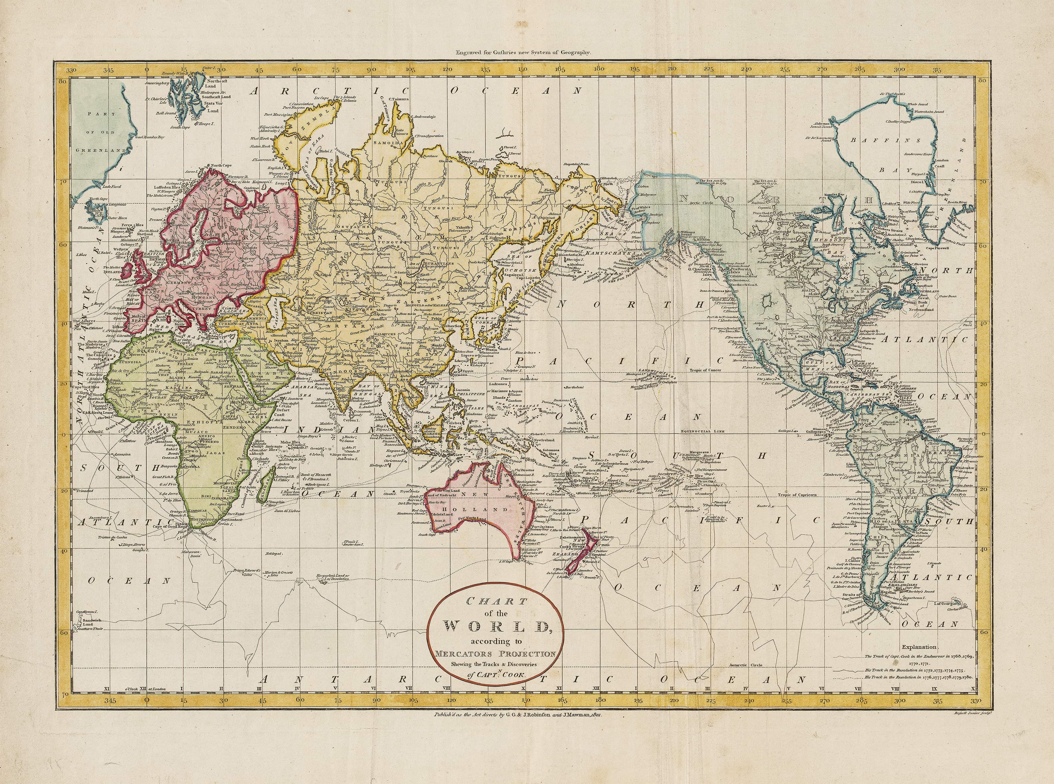
In a sweep of ink and latitude, this 1801 world map gathers the wake-lines of Endeavour, Resolution, and Discovery into a single breath-held portrait of the Age of Discovery. Track by track, Cook’s three voyages stitch the Pacific into focus; Vancouver and La Pérouse enter the scene, their routes crossing like threads as shorelines sharpen—Aotearoa New Zealand, Australia, the rugged Northwest Coast of America, the austere edge of Northeast Asia—while a speculative western inland lake in North America hints at questions still to be answered. Part chart, part chronicle, it lets you watch the world come into being—and hang that moment of human courage, curiosity, and seamanship on your wall.
🧭 A world taking form — Complete tracks of Cook’s three voyages (1768–1780), plus follow-on routes by Vancouver and La Pérouse for instant comparison.
🌍 The sharpened 1801 state — Later revisions refine coastlines for New Zealand, Australia, NW America, NE Asia, and Greenland.
🗺️ Elegantly unresolved — A newly depicted western inland lake in North America preserves the era’s best hypotheses on the eve of Lewis & Clark.
🏛️ Scholarly & beautiful — Period engraving style, neatlines and restrained shading read clearly from across the room.
Distinct voyage tracks annotated by dates/phases so you can follow landfalls at a glance.
Mercator projection with straight rhumb lines—classic navigation aesthetics and legibility.
Period finish preserved—engraver flourishes, graticule and careful coastline hatching for depth and clarity.
Clear Australasia & North Pacific—the map’s most improved regions in this later state.
By 1801, Cook’s circumnavigations had reset global expectations: the vastness of the Pacific made visible, Australasian coasts clarified, and North Pacific margins brought into sharper relief. This edition sits on that turning point—faithful to evidence, frank about unknowns, and alive with the momentum of Enlightenment science. It’s a document of method as much as mileage: observation, correction, revision.
Best for: framing under glass in studies and libraries
Look & feel: non-glare matte that preserves fine engraved linework and small labels
Best for: classrooms, shared spaces, research rooms
Build: sealed edge-to-edge between two 80-micron gloss sheets
Benefit: wipe-clean, durable, moisture-resistant
What you get: encapsulated print plus natural lacquered timber rails top & bottom and a discreet hanging cord
Where it shines: foyers, offices, schools, libraries—polished look with everyday toughness
Install: arrives ready to hang (just add a wall hook)
Lead time: please allow up to 10 working days for professional rail mounting
Best for: premium interiors, galleries, boardrooms
Print system: pigment-based, fade-resistant inks for long display life
Presence: textured surface adds warmth and museum-style depth
What you get: canvas fitted with natural timber rails top & bottom, matching cord
Where it shines: statement walls, curated displays, heritage spaces
Install: ready to hang; single-hook friendly
Lead time: please allow up to 10 working days for rail mounting
800 × 600 mm — refined and intimate; perfect above a desk or console
1350 × 1000 mm — balanced feature for living rooms, libraries and studies
1900 × 1400 mm — commanding centrepiece for boardrooms, galleries and public spaces
| Option | Best for | Key benefits |
|---|---|---|
| Paper (160 gsm) | Framing under glass | Matte clarity; crisp engraving detail |
| Laminated (encapsulated) | Busy/shared spaces | Wipeable; tough; edge-to-edge protection |
| Laminated + Rails | Ready-to-hang public display | Professional mount; easy install; durable |
| Canvas (395 gsm) | Premium display | Archival inks; textured depth; gallery appeal |
| Canvas + Rails | Gallery-ready feature | Period-true presentation; simple hanging |
Exploration wall: pair with a small caption card marking key dates/landfalls you care about.
Study corner: frame the 800 × 600 mm size and add a brass rail light for a warm scholarly glow.
Public foyer: choose Laminated + Rails for a polished look that’s robust to touch.
Gallery grouping: combine with Australasian or North Pacific regional maps to tell a fuller story.
| Detail | Description |
|---|---|
| Title | Captain Cook’s Voyages — World Map |
| Edition | 1801 (significantly revised from earlier states) |
| Projection | Mercator |
| Content Highlights | Tracks of Cook’s three voyages; routes of Vancouver & La Pérouse; refined outlines for NZ, Australia, NW America, NE Asia, Greenland; pre–Lewis & Clark inland lake depiction |
| Finishes | Paper; Laminated (encapsulated); Laminated + Timber Rails; Canvas; Canvas + Timber Rails |
| Lead Time (Rails) | Up to 10 working days (laminated or canvas with rails) |
| Orientation | Landscape |
| Production | Made in Australia |
Maritime & exploration enthusiasts tracing Cook against his contemporaries
Educators, libraries & museums teaching Enlightenment science and the Pacific world
Collectors & interior designers curating heritage-rich spaces with genuine scholarly appeal
Watch the world come into focus—track by track, landfall by landfall—through a faithful, beautifully produced replica that marries discovery with design, and turns a room into a conversation.
Ships within 48 hours · Estimated delivery Oct 20 - Oct 25
US$40
Get nowSign up to your membership to get coupons up to
15%
Get nowOpportunity to enjoy order discount up to 15% off
Top-Converting Item to Boost Your Average Order


